
Weslaco Neighbors by Block Source
A block search in Weslaco is a set of smaller checks, not a list of everyone living nearby. A parcel map can show adjacent lots and mapped features. HCAD or the tax account search can associate a parcel with an owner, situs, mailing address, and legal description. Recorded plats and deeds explain lot or easement relationships. Community sources can identify an association or local institution, but not a private membership list. The useful question is what each source actually shows about the immediate block.
| Source | What It Shows About a Block | Access |
|---|---|---|
| GIS parcel map | Adjacent parcel shapes, roads, and selected parcel links or layers | Historic county viewer URL; current live controls are unverified. |
| HCAD whole-street search | Owners and parcels associated with an address prefix | Public property or tax search; not an occupant list. |
| Recorded plats and deeds | Block, lot, easement, replat, and recorded owner sequence | County Clerk portal or historical microfilm. |
| Voter file | Registered voters in a permitted geographic extract | Controlled request; protected fields withheld. |
| City permits or code files | Dated applicant, owner, or agent information tied to an address | EnerGov or a targeted public-information request. |
| HOA certificate | Association or management contact information | Texas public certificate search; member rolls are private. |
Ownership and occupancy are different facts. An owner may use a separate mailing address, hold a parcel through an entity, or not live there. Conversely, occupants can have no recorded ownership interest. The block table therefore starts with parcel evidence and names the gaps instead of turning an address search into a claim about every household.
Note: Parcel ownership and current occupancy are separate questions, so record the source date and each field's stated meaning.
Map a Weslaco Neighboring Parcel
The adjacent-parcel method begins with the target lot and uses the legal description as a check. HCAD and county GIS share parcel data in the county's documented system. The historic GIS address is useful as a lead, but its current field list, layer names, and buffer tool were not verified. Use only controls visible in the current viewer, and do not call a map distance a legal boundary.
- Search the target address in HCAD or the tax account search and record the account, situs, and legal description.
- Open the county GIS viewer if it is live, pan to the parcel, and use the visible identify or select function.
- Click each parcel sharing a boundary or facing the same block. Record only the public parcel identifier, situs, owner or legal-description fields, and relevant confirmed layers.
- Check the subdivision plat and legal description before treating a rear lot, alley parcel, drainage tract, condominium unit, or common area as a neighboring residence.
- Use the County Clerk index for a dated deed relationship when the owner trail needs confirmation.
The broader by-address record chain belongs with Streets. It follows a named street through tax, deed, and historical tools. This narrower Weslaco neighbors workflow stays with the immediate block and the parcels that can be verified around one address.
Weslaco GIS Viewer Gap
Hidalgo County materials historically listed a public GIS portal at the county GIS address and describe shared HCAD parcel data, subdivision planning, contours, flood-control structures, emergency response, and voter-location uses. During research, the live viewer did not provide a usable public field inventory. Address search, parcel popup fields, named layers, and measurement controls must be checked when the map is open.
This is an important local limitation. Do not invent a buffer radius, a layer title, or an owner link that the live map does not display. When the map is unavailable, the fallback is HCAD or tax account data, the legal description, recorded plats, and the County Clerk's official records index. That sequence preserves a block trail without overstating the current GIS interface.
Note: Confirm live GIS controls before relying on a parcel popup, layer, measurement, or adjacent-parcel display.
Weslaco Parcels and Common Areas
Parcel geometry can mislead when every shape is treated as a home. A subdivision record can separate a rear lot, alley, drainage tract, condominium unit, road easement, or association common area from a residential parcel. Plats and legal descriptions are especially useful when the visible street pattern changes after a replat. The property search may show a parcel account while the recorded instrument explains the lot, block, unit, or phase behind it.
For an older Weslaco block, the parcel description often lasts longer than a street label. Hidalgo deed books and indexes documented by TSLAC reach back to 1852, while current online portal coverage does not state a complete historical starting point. A direct or reverse index, then the relevant deed book or plat, is the documented fallback when a current address search stops short.
Note: A common-area or drainage parcel can touch a residence on the map without representing a neighboring household or an owner-occupant relationship.
Weslaco Neighbors and Voter Data
The public Hidalgo lookup is not a block roster. It asks for an exact first name, last name, and date of birth, then supplies election-facing ballot and precinct context. It does not promise a full address, voting history, or a browse-by-street result. Texas voter information has a public and confidential split, and a non-match does not prove that someone is unregistered, absent, or not part of the neighborhood.
A geographic voter-file request is separate from the public form. The county or Secretary of State can advise on the proper request, medium, fee, permitted scope, and statutory restrictions. Protected voter addresses are suppressed for eligible participants, including those using confidentiality processes. Ballot choices are not public person-level data. These limits keep a Weslaco neighbors search from becoming a substitute for an election record request.
Weslaco HOA Certificate Contacts
Texas's HOA management-certificate search supplies a community layer that property maps do not. Search by county, city, ZIP, or association name. A certificate can identify an association or manager, but it does not disclose member households. The research located an Isabella Point Home Owners Associate result in Weslaco ZIP 78599. That identifies an organization lead, not a list of neighbors.
| Texas HOA search | Hidalgo County management-certificate search; search by name, county, city, or ZIP. |
|---|---|
| Isabella Point | Public certificate result identifies the association in Weslaco, ZIP 78599; member roster not shown. |
| Mid Point Estates HOA | Public site identifies 326 single-family homes, portal documents, contact, and 2208 Tomatillo Dr.; member documents and dues tools are for members. |
The Texas HOA certificate search is shown below in its Hidalgo County filtered form.
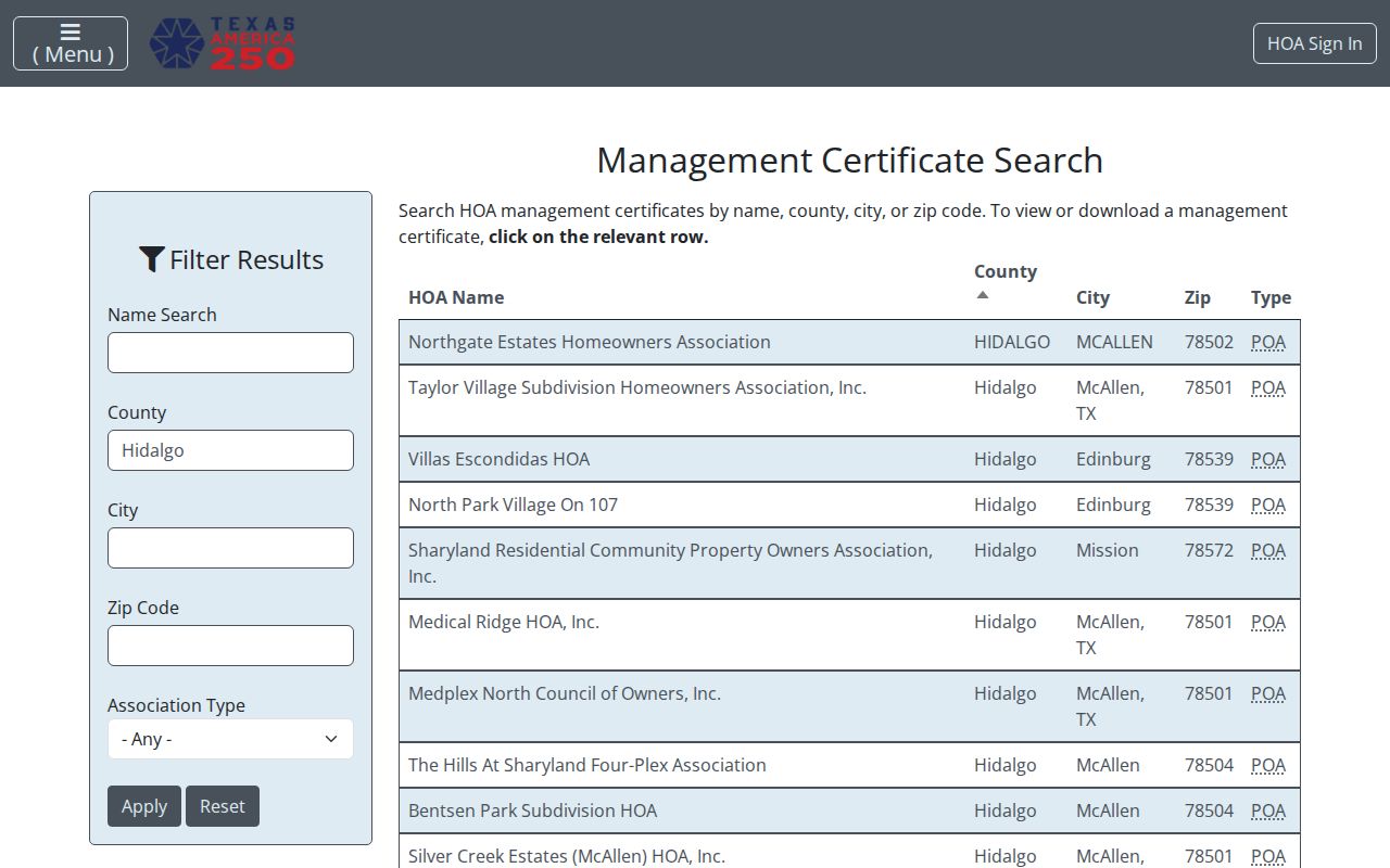
The visible search route supports a check for a community contact, not a personal profile. Contact the association through its published channel and respect any member-only portal boundary.
Weslaco Community Contact Boundaries
Community organizations can add context to a block without producing a private roster. The Weslaco Chamber public directory lists member businesses, categories, and Chamber contact information. Civic leads mentioned in local institutional materials include the Lions, Elks, Knights of Columbus, Valley Nature Center, and school alumni groups. Public event programs, newsletters, minutes, yearbooks, and contact pages may identify an organization, while membership lists generally remain private.
The Weslaco Museum exhibits and archives page is shown below because its formal research route is a local historical lead, not a neighbor database.

The museum accepts formal archive-research requests and keeps papers and artifacts in a records room. It can help establish historical family or institutional context. It does not publish a current block-level resident list.
Weslaco Official and Compiled Results
Official records and commercially compiled neighbor tools do different things. The official source identifies its custodian, date, field limits, and correction path. A compiled result may combine public property, court, voter, license, phone, or address-history data, but the combination can be stale, duplicated, or merged across similar names. Neither category converts parcel ownership into a current household census.
| Question | Official Source | Compiled Category |
|---|---|---|
| Who holds title to a parcel? | HCAD, tax data, and County Clerk instruments provide dated parcel evidence. | May repeat a prior record without showing its custodian or date. |
| Which lot touches the target? | GIS geometry, plat, and legal description can be checked together. | May group addresses without a confirmed parcel boundary. |
| How can an error be addressed? | Ask the named custodian for its correction procedure. | Use the provider's privacy or correction channel, then retain confirmation. |
The comparison favors a source-first method. Record the search date and document number, account, or parcel identifier. If a county record is missing from the web, request the existing record from the custodian rather than filling the gap with a commercial claim.
Keeping the street form, parcel identifier, and search date together also makes it easier to correct a mistaken block match without preserving unnecessary personal details.
Privacy Limits on Weslaco Neighbor Lookup
Public parcel adjacency does not make every person connected to a block public. Household members, children, visitors, utility customers, delivery records, and protected victims are not a public parcel output. A property owner can be absent or represented by an entity. A mailing address can be a post office box, business, or representative address. DMV personal information is protected under Texas law and is not a shortcut around those limits.
Texas Address Confidentiality Program participants can use substitute addresses, and protected voter processes can suppress residence information. Court, adoption, juvenile, medical, sealed, and expunged records have their own limits. Texas Penal Code sections 42.07 and 42.072 address harassment and stalking. Public records do not authorize unwanted contact, intimidation, following, or surveillance.
Lawful use. Use a Weslaco neighbor lookup for lawful personal research, community context, or a property question. Do not use information to stalk, harass, intimidate, or harm another person.